

A Chinese company’s publication of AI-enhanced satellite images of US bases in the Middle East is helping Iranian forces identify targets, US intelligence believes.
The ABC has been briefed on the intelligence by a source inside US defence, who says the images are endangering lives.
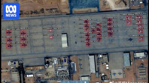
Chinese geospatial artificial intelligence and software company MizarVision, which the Chinese government has a small ownership stake in, has been publishing detailed satellite images with tagging data of multiple US military sites in the lead-up to, and during, the Iran war.
The imagery showcases an AI tool that identifies and tags military forces across vast areas, a capability that once required the resources of a national intelligence agency.
DLSS is essentially an advanced interpolation algorithm, it makes a guess of what should be in between two know pixel values. This can be very useful for human operators who need to look at the data. It also has the advantage that you only need a trained model and one image frame at a time. Some ‘superresolution’ methods essentially do this, but ideally you don’t use this until after you’ve applied mathematically correct techniques.
Superresolution methods exist in many forms. Basically all of them require either some prior knowlegde (or assumption) of what you’re looking at or it takes a lot of data. But once you have this, you can go beyond the optical resolution of your system in a mathematically correct way, you don’t have to guess!
Some examples: