

A Chinese company’s publication of AI-enhanced satellite images of US bases in the Middle East is helping Iranian forces identify targets, US intelligence believes.
The ABC has been briefed on the intelligence by a source inside US defence, who says the images are endangering lives.
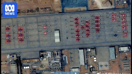
Chinese geospatial artificial intelligence and software company MizarVision, which the Chinese government has a small ownership stake in, has been publishing detailed satellite images with tagging data of multiple US military sites in the lead-up to, and during, the Iran war.
The imagery showcases an AI tool that identifies and tags military forces across vast areas, a capability that once required the resources of a national intelligence agency.
Oh I’m considering this from the perspective of the regional reason for instability which for a while now has been Israel. For long-term stability, Israel should face mutually-assured-destruction from Iran without the promise of unlimited weapons and interceptors from US. Israel should also face existential threat from Iran if they expand in to neighbouring countries, like they’re currently doing in Lebanon. If the US-Israel military command causes significant economic pain in the US, I think the US public opinion would force the US to break from Israel, which should usher the conditions I’m envisioning - of Israel facing Iran and the region alone, and perhaps even without unlimited US weapons. Def not the only possibility, but the one I think would make things a lot less explosive over the long haul.
E: I think China might push Iran to settle with the US in order to halt the economic destruction that would affect them too, possibly in exchange for greater economic China-Iran cooperation despite US sanctions.