

A Chinese company’s publication of AI-enhanced satellite images of US bases in the Middle East is helping Iranian forces identify targets, US intelligence believes.
The ABC has been briefed on the intelligence by a source inside US defence, who says the images are endangering lives.
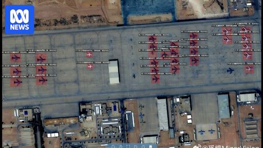
Chinese geospatial artificial intelligence and software company MizarVision, which the Chinese government has a small ownership stake in, has been publishing detailed satellite images with tagging data of multiple US military sites in the lead-up to, and during, the Iran war.
The imagery showcases an AI tool that identifies and tags military forces across vast areas, a capability that once required the resources of a national intelligence agency.
The time to do that was before bombing hundreds of Iranian children. And civilian infrastructure. Way too late now.
Are you expecting me to defend the Trump Admin? It’s never too late so long as the IRGC holds power, but yes he’s made it a lot harder for us to accomplish positive change.
No I’m just saying you might as well give up on that dream - the regime will have more support than ever, now.
We’re discussing hypothetical outcomes, I doubt any one of the suggestions in this thread will have any real world impact but remaining silent would be stupid.
Your problem here is that you think that “we” can accomplish any positive change. Only Iranians can do that. What “we” want to do is further our imperial domination of the globe.
For the moderate wing of the imperial powers (i.e. your “we”), that means toppling the state and replacing it with a pliant comprador regime which will privatize resources and reduce labour protections and the social safety net, enabling greater profits to flow back into the imperial core and to western companies. As a side benefit and for PR, this would also entail some opening up in terms of social liberties, which would be the “positive change” you’re talking about, but it’s both entirely optional and only at the expense of looting Iran.
For the extreme wing of the imperial powers, which is to say Israel, the goal is to completely destroy the Iranian nation and turn it into a fragmented, forcibly deindustrialized basket case that has no ability to threaten the goal of Greater Israel.
In short, while you probably don’t realize it, you’re articulating a position which is still ultimately hostile and detrimental to the Iranian people and to the middle east as a whole - just not as much as the faction that’s aiming for the destruction of Iran. A neoliberal comprador regime in Iran would be friendly with Israel, so the Greater Israel project would remain unopposed except by scattered resistance groups which could be dealt with piecemeal, and the overthrow of the Iranian state would therefore usher in genocide and forced displacement across the region.
Thus, the only moral and rational position is full support for the Iranian state, in spite of its flaws.