

A Chinese company’s publication of AI-enhanced satellite images of US bases in the Middle East is helping Iranian forces identify targets, US intelligence believes.
The ABC has been briefed on the intelligence by a source inside US defence, who says the images are endangering lives.
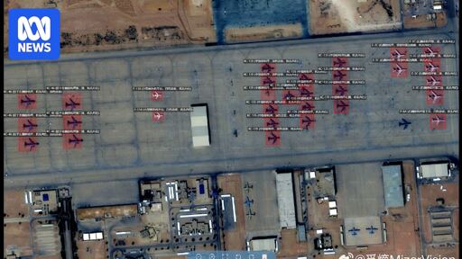
Chinese geospatial artificial intelligence and software company MizarVision, which the Chinese government has a small ownership stake in, has been publishing detailed satellite images with tagging data of multiple US military sites in the lead-up to, and during, the Iran war.
The imagery showcases an AI tool that identifies and tags military forces across vast areas, a capability that once required the resources of a national intelligence agency.
Russia and China watch US pull a Ukraine and now have an extremely cost-effective way of harming or outright destroying US assets similar to US dumping its spare power into the Ukraine conflict.
They’d be fools not to take advantage of the opportunity, but not nearly as foolish as we were for entering this pointless war in the first place.
It’s not pointless, the idea is to destroy the only remaining impediment to Israel’s growth. With Iran removed from the picture, the whole region can be turned into a charnel house, with Israeli settlements and startups built upon the bones of the slaughtered Arabs. The whole middle east replaced by a second America, but even more fascist.