

A Chinese company’s publication of AI-enhanced satellite images of US bases in the Middle East is helping Iranian forces identify targets, US intelligence believes.
The ABC has been briefed on the intelligence by a source inside US defence, who says the images are endangering lives.
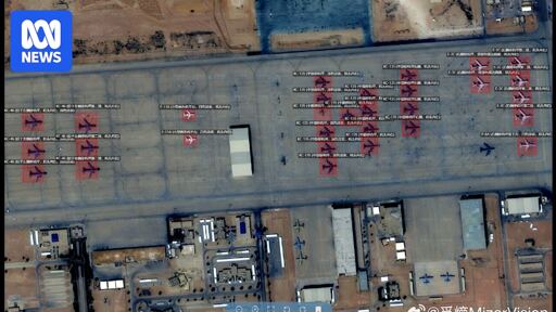
Chinese geospatial artificial intelligence and software company MizarVision, which the Chinese government has a small ownership stake in, has been publishing detailed satellite images with tagging data of multiple US military sites in the lead-up to, and during, the Iran war.
The imagery showcases an AI tool that identifies and tags military forces across vast areas, a capability that once required the resources of a national intelligence agency.
Well thats too bad.
Everyone had a nice easter? I hope you guys have monday off as well. I’m eating some crisps and watching DankPods
Based comment, have an upvote good Sir and a splendid easter!